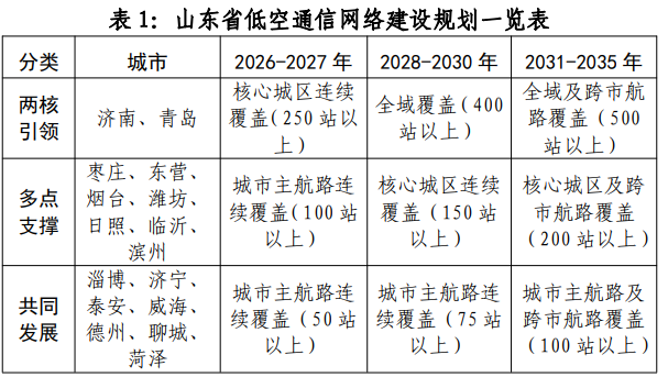
On October 27th, the Shandong Provincial Administration of Communications and other departments issued the "Special Plan for Low altitude Information Infrastructure in Shandong Province". Among them, it is proposed to support the construction of unmanned aerial vehicle intelligent logistics system. Support cities such as Jinan, Qingdao, Dongying, Yantai, Linyi, and Binzhou to take the lead in opening B2B and B2C logistics delivery routes for unmanned aerial vehicles, laying out the 5G-A network required for "dry support terminal" unmanned aerial vehicle delivery, exploring new smart logistics models of "unmanned aerial vehicles+unmanned warehouses", and promoting the large-scale application and landing of unmanned aerial vehicle delivery in emerging scenarios such as cities, rural areas, mountainous areas, and islands.
Partial content attached
Development Goals;
By the end of 2030, realize the continuous coverage of the provincial low altitude communication network throughout the city and the full scene interconnection of manned UAV routes, integrate communication, navigation, monitoring, meteorology and other data resources, further meet the monitoring, management and scheduling needs of the provincial low altitude flight management service platform, and actively explore the integration of low altitude communication network and satellite Internet into an integrated space space network.
By the end of 2035, we aim to build an intelligent, fully covered, highly reliable, and secure low altitude communication network digital infrastructure that integrates air, space, and ground, sensing, computing, and intelligence. This will provide ubiquitous connectivity and perception capabilities for the prosperity of the low altitude economy, ensuring that low altitude flights are visible, manageable, safe, and efficient.
Key tasks
(1) Strengthen the coverage of low altitude communication networks
Airspace below 600 meters: Reuse 3% of the existing 5G site resources in the network, accelerate the construction of a low altitude communication dedicated network, achieve 99% coverage and continuity, with response latency as low as 1 millisecond, fully meet the needs of unmanned aerial vehicle payload and non payload data transmission, as well as 5G networked collaborative unmanned aerial vehicle RID supervision information transmission. At takeoff and landing sites/points, air routes, and key security areas, a low altitude surveillance network system with integrated perception should be built as needed to enhance comprehensive situational awareness and ensure the safe and orderly development of low altitude economy.
Areas with weak coverage such as 600 meters above and remote sea areas: introduce satellite communication as an effective supplement, ensure seamless and continuous communication through the deep integration and coordination of 5G-A and satellite Internet, achieve compatibility with the data interface of low altitude communication network platform, and complete the unified aggregation and processing of multi-source data.
(2) Building precise navigation and positioning capabilities;
Based on the three working states of aircraft takeoff and landing, flight, and obstacle avoidance, the low altitude communication network integrates satellite positioning and RTK real-time dynamic differential positioning technologies to meet the navigation requirements of different accuracy requirements.
(3) Strengthen real-time monitoring capability;
Build a collaborative, intelligent, and efficient real-time monitoring system that integrates sensing and surveillance, achieving precise detection and dynamic control of low altitude aircraft, birds, and other targets, supporting the safe operation of low altitude economy and the intelligent upgrade of airspace management.
(4) Deploy cloud edge network collaborative low altitude intelligent computing system;
(5) Support the creation of a low altitude fusion perception platform;
Encourage information and communication enterprises to actively participate in the construction of low altitude fusion perception platforms. Southbound completion of 5G-A integrated communication and sensing equipment, radar TDOA、RID, Fitting multi-source data such as cameras to build multimodal fusion perception capability; Northbound docking with the city level low altitude flight management service platform and providing aggregated data streams to assist in the docking of the city level low altitude flight supervision service platform with the platform systems of air traffic management agencies and civil aviation management departments, in order to have service functions such as networked equipment management, flight plan declaration, plan review and approval, low altitude digital airspace planning, flight situation supervision, flight anomaly alarm, information announcement, flight data collection, organization and analysis, providing end-to-end information service support for individuals, enterprises, regulatory departments and related operating agencies, and realizing full visibility and management of low altitude flight activities.
(6) Develop standard specifications for low altitude communication networks;
(7) Promote innovative applications of low altitude economy;
Relying on the wide coverage capability of low altitude communication networks, following the principles of cargo transportation before passenger transportation, isolation before integration, and suburban areas before urban areas, we aim to support the development of innovative low altitude economic applications in production operations, public services, logistics distribution, low altitude transportation, cultural tourism, and other fields in our province.
1. Support the low altitude application of production operations. In the field of agriculture, supporting unmanned aerial vehicles to accurately complete pesticide spraying, fertilizer sowing, and seed delivery, improving operational efficiency, reducing pesticide usage, and cooperating with the construction of an integrated monitoring network of "sky, earth, and sky" to dynamically capture crop growth, soil moisture changes, and guide precise fertilization, radiating and driving farmland yield increase. In the fields of energy and power, support the regular inspection of low altitude equipment, quickly detect equipment defects such as overheating and damage, and greatly improve inspection efficiency and accuracy. In the field of mineral exploration, support the rapid completion of terrain mapping and mineral distribution detection in mining areas, improve the efficiency of ore body location delineation, and reduce exploration costs. In the fields of bridges, tunnels, and other engineering projects, support terrain surveys before construction and generate centimeter level precision digital elevation models to reduce engineering changes. In the field of forestry production, support the integrated operation of low altitude equipment afforestation and sowing, disease and pest warning, as well as ecological monitoring and tourism resource survey. In the field of meteorology, support unmanned aerial vehicle (UAV) operations such as weather modification and atmospheric detection to enhance the ability of meteorological protection for ecological civilization.
2. Support the construction of a low altitude public service system. Focusing on forest firefighting, maritime rescue, and hazardous chemical accident rescue, accelerate the application of 5G-A low altitude communication network in the field of emergency rescue. Key support will be given to pilot aviation medical services in Jinan and Qingdao, and the application scope of aviation medical rescue will be expanded as needed. Explore the implementation of low altitude policing pilot projects, extensively carry out patrol and prevention, investigation and search, traffic law enforcement, accident handling, emergency response and other work, and enhance the efficiency of social governance.
3. Support the application of urban air traffic acceleration. Collaborative implementation of 5G-A communication perception network technology adaptation for innovative applications of smart air travel (SAM) equipment such as eVTOL in urban air traffic. Moderately advance the coverage of low altitude communication perception networks required for takeoff and landing sites/points and air routes, to meet the demand for passenger transportation distribution on railways, aviation and other trunk lines, to create short distance transportation brands such as "flying along the Yellow River" and "flying across the sea", to promote the connection and interconnection of "trunk and branch lines", to cultivate new forms of manned air transportation such as business travel, air shuttle, private charter flights, etc., and to provide corresponding guarantees for meeting flexible and diverse travel needs.
4. Support the construction of unmanned aerial vehicle intelligent logistics system. Support cities such as Jinan, Qingdao, Dongying, Yantai, Linyi, and Binzhou to take the lead in opening B2B and B2C logistics delivery routes for unmanned aerial vehicles, laying out the 5G-A network required for "dry support terminal" unmanned aerial vehicle delivery, exploring new smart logistics models of "unmanned aerial vehicles+unmanned warehouses", and promoting the large-scale application and landing of unmanned aerial vehicle delivery in emerging scenarios such as cities, rural areas, mountainous areas, and islands.
5. Support the expansion of the low altitude consumption market for cultural tourism. Encourage cross industry cooperation among communication and various enterprises, explore and cultivate the consumer markets for low altitude tourism, aviation sports, private aviation, and business aviation in our province. Strengthen the integration and application of 5G-A low altitude communication network in key tourist areas such as the Yellow River, Wonderland Coast, and Red Yimeng. Strengthen the innovative application of 5G-A in flight experience and aviation skydiving consumption flight activities, with a focus on on-demand coverage of aviation sports clusters in counties (cities, districts) such as Laiwu, Shanghe, Penglai, Qixia, Feixian, and Lanshan.
(8) Strengthen network and data security protection;
(9) Enhancing factors to support the improvement of the industrial chain;